Cottonwood Marble Canyon Loop FKTs
It’s official: we love Death Valley so much that we got a Death Valley bumper sticker for the truck. I think that’s a pretty major statement. It’s one of the few places I’ve ever seen Cordis and I go into a gift shop and be absolutely delighted. Postcards! Stickers! Let us commemorate our love for this place in all forms!
My first trip to Death Valley was around New Years Eve in 2015. I came by myself in the Jeep, the norm for my California days. I camped at Emigrant and got rocked by wind in my one-person tent all night long. I went for a 6 mile trail run and was absolutely entranced by the sense of isolation I felt. This 2015 trip already fell during a very isolated chapter of life, and to be honest I was beginning to bask in it a little: did I even need anyone else? My Jeep and LA and I could ride out the rest of our days as a great triumvirate.
I find solo time to be the great test: can I sit with myself? Do I need an audience? It has a way of revealing foundational cracks. I’ll be forever grateful for this chapter and the many thousands of miles I roved with myself and my Jeep; for the gift of later falling in love with a partner who was in a similar place. It’s been foundational to our relationship to have arrived with a history of being content as individuals.
I often think of this as it relates to ultras. Sure, there are the miles early or late in an ultra where you group up with others. But the majority of miles I’ve run in ultras have been with me, myself and I. And maybe the sweaty butt of someone in front of me. Can I push when no one’s watching? Can I enjoy it without company?
I think what I’m trying to get at is the challenge of sitting with yourself is core to Death Valley as an experience. Can I take care of myself? Am I okay with finding my own way? I’ve found that on the other side of those questions are where some of the greatest, self-propelled ultra experiences lie.
So as we sat in our Las Vegas hotel room on a rainy Saturday afternoon trying to figure out where we’d run long the next day, our hearts leapt when we found a way to get back to Death Valley. The Cottonwood Marble Canyon Loop. 50k, long climb up one canyon, long descent down the other, and even a history of FKTs! Not to mention, we are real suckers for a loop.
We’d just raced Red Hot 55k the weekend before, but Cordis had been recovering without any issue and knew he’d go for the FKT. Meanwhile, I’d been nursing some niggles back to life after Red Hot and wasn’t so sure about setting any records. But my energy levels felt great, so I figured at the very least, I’d start and could always cut short if needed.
So we hit the road with coffee around 7:00am from Las Vegas and made the two hour drive out to Death Valley, passing great desert classics like Area 51, Nevada Test Site, and the historic mining town of Rhyolite. This approach into the valley was a new one for me and I loved it. Cresting over Daylight Pass, we literally squealed when we saw a very snowy Telescope Peak (where we set a mixed-gender team FKT in the fall!)
The bumpy road from Stovepipe Wells up to the trailhead was NOT mellow, internet. I had Cordis holding the gear shifter in the drive position because the car was rattling so hard it would fall into neutral!
Cordis started at 10:30AM, looking fresh! I cleaned some crap out of my soft flasks, changed clothes and got to it at 10:49AM.
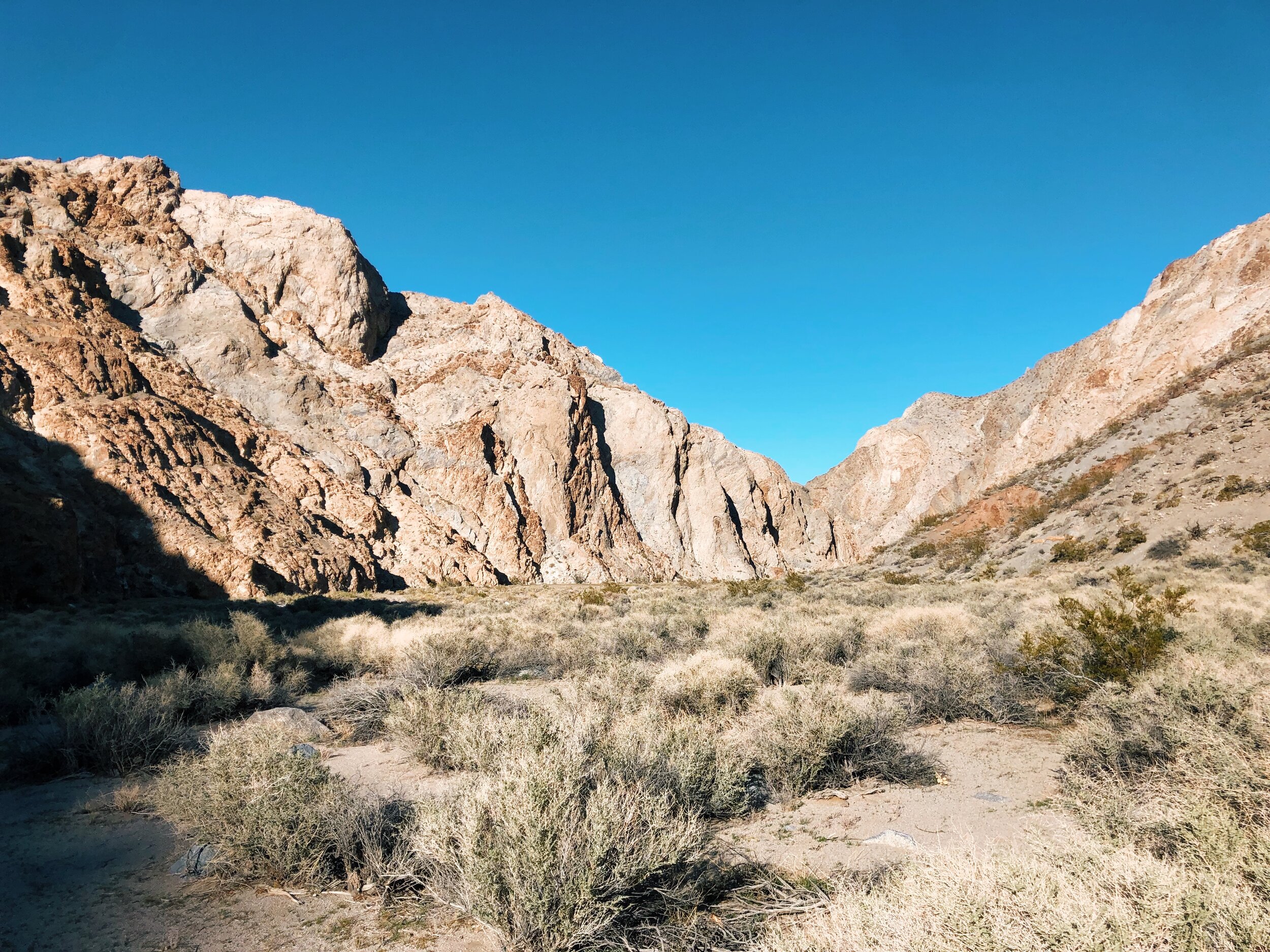
After a couple miles of rocky 4x4 road, I reached the fork where the two canyons met and turned right. We both chose to start by going up Marble Canyon, mainly because we’d read Cottonwood was softer under foot and we both preferred that as a descent. It was only a few minutes before the canyon started to rise high around me on both sides.
The miles actually flew by through here. I knew water management would be core to the day, so I sipped slowly. I brought 7 Spring gels with me, and opted to front-load my calories by eating one every 30-45 minutes (I wanted to be at my sharpest for the remote, middle miles, 13-20.)
I saw a hiker who condescendingly inquired, “Are you with the other guy I saw? He’s WAY ahead of you. You should take the bypass.” A bit pridefully, I cheerfully replied, “All good, just trying to catch him!” Little did I know the bypass he was referring to was to get around the massive chockstone just ahead, that was clearly not passible. Good thing *that* wasn’t the dryfall boulder problem I’d read about.
Soon, the rock changed from red and rough to smooth and gray, and got as narrow as 5-6 feet between walls. I ran my hands along the glassy, cool walls, talking out loud to myself about how fascinating it all was. After a somewhat abrupt left turn, I was grateful to have put the route on my Suunto. (To be honest, I’ve never actually used this feature on my watch before and was shocked at how easy it was.)
I was now entering the part of the route I’ll call “the messy middle,” where it gets a bit more meandering and less clear overall as to where you’re actually heading. Lizards rustled in the willows, constantly darting across the trail in front of me.
After following a dry creek bed for a ways, I finally reached the dryfall I’d read lots about on the internet, which was a pretty simple little two-move sequence. The only thing remotely scary about it was the steadily decreasing margin for error as I went deeper into the route. I also knew that this little move meant I was doing the whole route - which I was thrilled about. The body felt great and the effort felt easy and low so far.
That’s an interesting aspect of remote routes that Cordis and I were discussing after - how important it is to stay below your red line all day. In a race, you can take far more risk, where you’re rarely more than an hour or so from the next aid station. To run that hard unsupported in a remote location becomes almost irresponsible.
Shortly after the dryfall, I made the cut left up a corner between two steep hills into some lovely desert high country. What visually seemed like it would be the high part of the route was not, but it was the airiest summit of the day. The sagebrush-filled, rolling terrain that now surrounded me left me wondering, “where exactly AM I?” I reached this open landing around 2:18, just shy of the halfway point.

Wandering through some almost Sierra-like high country, I finally reached the true summit at 2:41. From here, the route becomes increasingly unclear until around mile 22.
Despite how lovely the morning in Marble Canyon had been, I was suddenly thrilled to be in the wide, open valley. My run turned into a bit of a gallop and I had the thrill that comes from being “in it.” I ran into a group of three women hiking and asked if they’d seen any of the wild horses! They said just a mile and a half ahead which I was thrilled about.

I started to make out what I believed to be Cottonwood Canyon, and the grove of massive trees and greenery was the giveaway. A mile and a half later, I’d seen plenty of wild horse poop but no wild horses. I scuttled down to the river where I found a giant patch of seemingly-neon green clovers, and thought, “Now THAT’S my water source.”
The horse poop didn’t deter me too much (“that’s what filters are for!”) but what always gets me in these instances is the thought, “this water will help me live now, and I will deal with giardia from the luxury of civilization when it comes.” A good ole cross-that-bridge-when-I-get-to-it ethos.
After filling my water, I went back up the hill, but saw that it appeared it was going to cliff out. I went back down to the creek, figuring it would follow the mucky bank of the creek for a bit. I poked around, but nothing seemed right. I went back up the hill, back down once more, and then back up once more, retracing my steps until I found a more logical turn that avoided the cliff band.
Even after that, there were several instances of pre-panic, when I considered what getting lost meant at this point. (Out and backing into a 40 mile day. I suppose there are worse things.) At this point in the day was when I started to think, “This route is pretty legit.”
I read this terminology on another trip report recently (I can’t recall where) - “the trail was just as easy to lose as it was to follow.” That’s a great way of summarizing the south end of Cottonwood Canyon. But as though we were playing Marble Canyon in reverse, it became more and more prominent as I descended, until I turned a distinct corner to find a two-track road waiting for me. YES!
Basking in what the day had been, I enjoyed the final 8-10 miles of dirt road, tumbling the 4,000 foot descent nearly giddy. I saw the two hikers who’d been hitting the trail when I left 5 hours before. I wondered what they thought of goofy Cordis and I, probably quite far apart, all kitted, hardly a thing on our backs.
I worry hard when we divide and conquer, so all day my mind had been playing out every scenario. I was delighted when I turned the corner to see sweet Cordis, sitting in the Love Bench (our beloved two-seater camp chair) with a half-full jug of kombucha.

“Did you do the whole thing?!” He yelled.
“Yep!!!”
Man, these moments don’t get old.
The Panamint Range was starting to turn gold. Cordis ran 4:39 and set a new men’s FKT, which was no surprise. These kind of routes are his forte.
Returning to the car safe and sound, accomplishing what we’d set out to do - I swear there’s no better feeling in the world. As we hopped back in the truck, the washboard road didn’t feel quite as bumpy this time. The sky turned a soft pink and we drove back to Vegas.

Thanks to Fastest Known Time for maintaining a site and standards for this sort of thing. It’s truly beautiful and the uplifting community of individuals that pursue these feats makes my heart sing.